|
And to think this web site all started as the result of a High School Student Project back in 2000.
(South Kitsap High School - Port Orchard, WA.)
* * * * * *
A Not-for-profit IRS 501 (c) (3) "Public Charity".
Federal ID No: 91-2136205
|
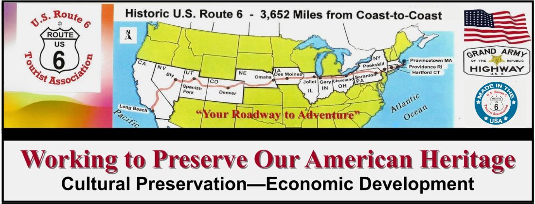
Exploring the Rich History of Route 6
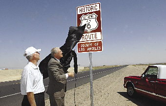
Sign Dedication - Lancaster, California
From Left; Fred
M. Hann, formerExecutive Director of the California U.S. Route 6
Tourist Association - State Assemblywoman Sharon Runner - Norm Hickling, Field Deputy for Los Angeles County
Supervisor Michael D. Antonovich - Betty Hann - Richard
Saunders, Advisory Committee member and Carlos Valdez, Event
Coordinator.
(Carlos is the
owner of the "COOL" 1954 yellow Ford pickup truck)
2007 - 2008
With the support of individual SPONOSORS, member businesses and
communites in the State of California the U.S. Route 6 Tourist
Association drafted a Resolution that was sponsored by
Assemblywoman Sharon Runner of Lancaster, California. The
Resolution restored the coast-to-coast integrity of the Grand Army of the Republic Highway that was lost in 1964 as a result of renumbering.
State Resolution ACR 26 approved on July 03, 2007 recognizing
the historical significance of the pre-1956 alignment between
the Nevada state line and the City of Long Beach, California.
Historic US 6 Route signage has been installed in the member
Cities of Lancaster, Palmdale and Santa Clarita.
Signage was recently (Summer 2008) completed within the
jurisdiction of Los Angeles County between Kern County and
Highway I-5.
ROUTE 6 RECALLED (June 11, 2008)
Los Angeles County Supervisor Michael D. Antonovich, right, and former Lancaster mayor Fred M. Hann, Executive Director of the California U.S. Route 6 Tourist Association, on Wednesday unveil a new Historic U.S. Route 6 sign on Sierra Highway at Avenue G. The County plans to erect 12 more signs between the Kern County border and Interstate 5 in Santa Clarita.
* * * * * * * *
From Bishop south to Long Beach, Historic US 6 signs are being
established along State Highway 395 and Highway 14 into Mojave
and from Mojave south along the Sierra Highway (historic
alignment) through Lancaster and Palmdale to Santa Clarita. From
Santa Clarita south US 6 is known as San Fernando Blvd. / Rd.
and passes through the Cities of San Fernando, Burbank
and Glendale. From Los Angeles it travels south on Figueroa
Street through the Cities of Carson and Wilmington, then east on
the Pacific Coast Highway into Long Beach and then south to the
end of Long Beach Blvd. where it ends at Ocean Blvd.
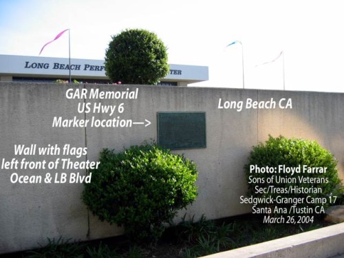
Look across Ocean Blvd. and you will see the Long Beach
Performing Arts Theater. On the landscaped wall in front of the
theater is a plaque showing this to be the westerly end of 3,652
miles of Historic U.S. 6, also known as the Grand Army of the
Republic "Memorial" Highway.
In 1953 the plaque was located a couple blocks away on the
nearby waterfront.
* * * * * * * *
The Associations next project will be to create detailed highway
maps showing the original pre-1956 alignment as it exists today.
This challenging project will only come to fruition through the
help of volunteers and the financial support of SPONOSORS. Thank you to all who continue to support our work and
a warm welcome to anyone interested in joining us as a member of
the team.
Always feel free to
contact us should you have any questions. |
|
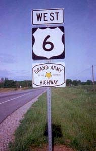
The Grand Army of the Republic (Memorial)
Highway
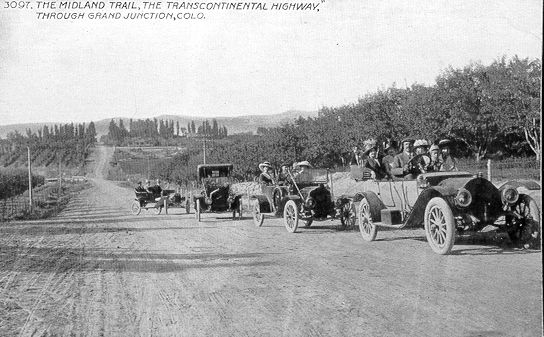
(The King's Highway, Roosevelt Highway, and the Midland Trail, etc.)
The Grand Army of the Republic (Memorial) Highway is the
present official name, however, during the late 20s and early 30s it was also known as the
Roosevelt Highway, after President Theodore Roosevelt. Prior to 1926 it was called
(in-part) the Midland Trail Roadway.
The Historic
Highway began as an entity in November of 1926 when the American
Association of State Highway Officials (AASHO) adopted the U.S.
numbering system for marking the Nation's main Interstate highways.
The Grand Army of the Republic (Memorial) Highway is the
present official name, however, during the late 20s and early 30s it was also known as the
Roosevelt Highway, after President Theodore Roosevelt. Prior to 1926 it was called
(in-part) the Midland Trail Roadway.
The Historic
Highway began as an entity in November of 1926 when the American
Association of State Highway Officials (AASHO) adopted the U.S.
numbering system for marking the Nation's main Interstate highways. Historic U.S. Route
6 --- Coast-to-Coast Through 14 States
At this point,
U.S. Route 6 was still just a patchwork of mis-matched highways. Writer/Historian George
R. Stewart commented that, "Route 6 runs uncertainly from nowhere to nowhere,
scarcely to be followed from one end to the other, except by some devoted eccentric."
However, it lost its transcontinental status in 1965 when AASHO approved a request from
the State of California to end the Historic Highway at the Town of Bishop. Currently, U.S.
Route 6 is 3,227* miles long, making it the second longest U.S. Route in the country. U.S.
Route 20 is now classified as the longest route at 3,345* miles. Much of the original
alignment remains intact between Bishop and Long Beach, California. I can only hope that,
someday, the State of California will properly post these remaining portions of this
famous Highway.
The West End Question
Over the years there have
been several different west endings to Historic U.S. Route 6, and all were located in the
City of Long Beach, California. The big question is, at which location did it actually
end? Our archives reveal the following three documented endings.
Prior to 1953 the
Historic Highway ended at the east end of town, at the Long Beach Traffic Circle.
In 1953 Route 6 ended at
the water front at the Long Beach Municipal Auditorium. It was here that the Grand Army of
the Republic Association(G.A.R.) held an official U.S. Route 6 Encampment. A bronze plaque
was placed on the outside of the wall of the Auditorium which identified this location as
the westerly end of U.S. Route 6. The Auditorium was located at the intersection of what
is now Long Beach, Blvd. (Old Route 6) and Seaside Blvd.
As an item of interest,
the Long Beach City Council officially authorized the placing of temporary U.S. Route 6
signs along Long Beach Blvd. in order to direct G.A.R. encampment traffic to the
auditorium. Because of this, U.S. Route 6 is officially known as The Grand Army of the
Republic Highway.
Prior to 1953 it is said that the West End was in Wilmington at the intersection of Figueroa Street and the Pacific Coast Highway. However, we have no documents to support this as a fact. (back to researching the archives)
For additional information about the West End
Historic US 6 Highway ends in Long Beach CA
So where is the location
of the bronze plaque today?
After
the Municipal Auditorium was torn down in the 60s, a monument marking the west end of the
Historic Highway was relocated on the wall of the Terrace Theater, located on the south
side of Ocean Blvd.
On January 23, 2001 the
Association received a letter from the Historical Society of Long Beach which informed us
that the plaque is now located on Ocean Boulevard near the Long Beach Performing Arts
Center, formerly known as the Terrace Theater.
Should anyone reading
this text have any questions, or knows of any other historical facts about the west end of
Route 6, I would appreciate hearing form you.
Russ Lombard, President
U.S. Route 6 Tourist Association
08/2001
PLAQUE AT THE WEST END
( Pictures Taken - March 26, 2004)
Thanks to the Historical Society of Long Beach, California,
and to Floyd Farra, Historian with the Sons of Union Vetrans,
we now know the current location and have some pictures of the
Plaque which established the West End of Historic U.S. Route
6 on May 3, 1953. The Plaque is located on the wall in front
of the Long Beach Performing Arts Center at Ocean and Long Beach
Boulevard.
The Historical
Society of Long Beach
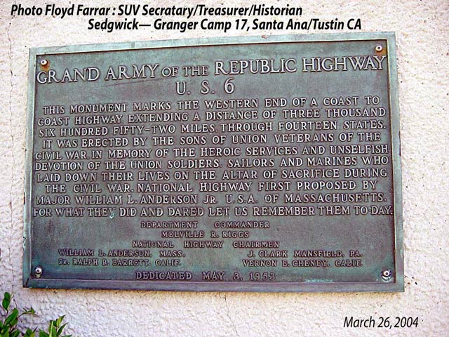
The Plaque
On the wall
|
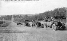
- Picture From the Colorado State
Archives.
- Road Sign Located East of Bishop, CA Looking
Towards the Nevada State Line. Photo by Mike Blubaugh 8/4/2001
|
|
|
US ROUTE 6 - COAST TO COAST CHARITY RUN

Singer To Run Across the Country for South Bay Charities
By Keith Burbank BAY CITY NEWS
April 25, 2015
Coast-to-Coast
3,652 miles
Charity Run - Aprylle Gilbert - Morgan Hill Times
April 10, 2015
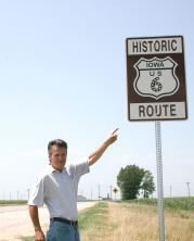
IOWA - February 2014
CPC (The Atlantic Community Promotion Commission) approves funding for Historic Route 6 signs
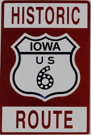
IOWA - August 2013
Historic Route 6: Classic car trip starts here
|
| |
IOWA - March 2013
U.S. 6 - The Grand Army of the Republic Highway |
| |
NEBRASKA - Sept. 2012
Ashland Historical Society - Ready For Visitors At New Office |
| |
IOWA - July. 2012
Iowa's U.S. 6 - History Noted ... Quad-City Times - July 23, 2012
|
| |
IOWA - June. 2012
County road dubbed 'Historic Route 6' |
| |
IOWA - June. 2012
Get your kicks on Route 6: Area towns will use sign language..MuscatineJournal |
| |
Press Releas - Yahoo.com
Author Malerie Yolen-Cohen Announces Release of Stay on Route 6: Your Guide to All 3652 Miles of Transcontinental US Route 6 |
| |
IOWA - May. 2012
Old 6 gets its proper name back : Quad-City Times: Quad Cities, IA/IL |
| |
| |
COLORADO -
Dec.. 2011
Harms marks 50 years as Town of Paoli mayor |
| |
| |
CALIFORNIA - Sept. 2011
Firm completes spacecraft factory in Mojave - latimes.com |
| |
| |
OHIO - July 2011
Lakewood And The Civil War - Lakewood's Blue Ghost Army? |
| |
CALIFORNIA - July 2011
Destination Lancaster in the heart of the Antelope Valley, CA |
| |
NEBRASKA - July 2011
The Ashland Gazette > Linoma Beach Lighhouse > Summer Hot Spot! |
| |
| |
CALIFORNIA - June 2011
Travel Writer Makes Cross-Country Trip On Historic Route 6 « CBS Los Angeles |
| |
IOWA - June 2011
Omaha Newsstand >Cruising Into Wilton-PDF file |
|
|
NEBRASKA - June 2011
Omaha Newsstand > The Ashland Gazette > "Stay on Route 6" |
|
|
IOWA - June 2011
Highway 6 cruise to stop in Newton Friday - Newton Independent |
|
|
IOWA - June 2011
Classic car and hot rod owners invited to cruise US Route 6 - Quad Cities Online |
|
|
IOWA - April 2011
Walcott, Iowa: Open for business along the 6 - QCtimes.com Quad City Times Newspaper |
|
|
NEBRASKA - March 2011
Historical society joins U.S. 6 Tourist Association - The Ashland Gazette |
|
|
NEBRASKA - February 2011
Gretna vote a boost for outlet mall - Omaha World-Herald |
|
|
| |
ILLINOIS - December 2010
Joliet landmarks world’s first ‘DQ’ - Beacon News |
|
|
NEBRASKA November 2010
Gretna Downtown Association meets with Route 6 Association |
|
|
IOWA - November, 2010
Bank bistro gives Ladora something to sing about - The Quad-City Times
|
|
|
NEBRASKA - October, 2010
Investors plan to restore Linoma - Ashland Gazette |
|
|
|
|
CALIFORNIA - August, 2010
(Human Interest Story & Slide Show - Los Angeles, CA)
Girl's downtown accordion practice puts spring in their step - latimes.com
|
|
|
CALIFORNIA - August, 2010
The American Tour - The Santa Barbara Independent
|
| |
|
|
PENNSYLVANIA - July, 2010
PA's Route 6: Driving Through "God's Country" | Frommers.com |
| |
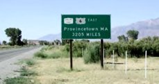
MASSACHUSETTS - July, 2010
P'town touts Route 6 as link to California | CapeCodOnline.com |
| |
|
|
|
|
|
|
UTAH - Jan. 2010
ksl.com - Stats show US Highway 6 is a safer road to drive |
| |
UTAH - Jan. 2010
Highway's name irks descendants of Civil War vets - Salt Lake Tribune
|
| |
MASSACHUSETTS - Jan. 2010
Westport sees growth potential in Route 6 area
|
| |
IOWA - Dec. 2009
Discarded sign marked historic road |
| |
| |
| |
| |
PENNSYLVANIA - Sept. 2007
Officials: Route 6 museum would boost revitalizations
- from Meadville Tribune * |
| |
NEBRASKA - Aug 2007
Traveling Highway 6 by two-wheeler-McCOOK Daily Gazette |
| |
| |
PENNSYLVANIA - July, 2006
PA's Route 6: Driving Through "God's Country" | Frommers.com |
| |
| |
NEBRASKA - Oct 2005
McCook
Daily Gazette: Story: Cabin has new home in Holbrook park
- updated 02/10/2021 * |
| |
UTAH - Aug. 2005
Truck Carrying Explosives Blows Up in Utah August 11, 2005
U.S. 6 motorists must find new route
|
| |
NEBRASKA - Jul. 2003
U.S.
Highway 6 - a national treasure
McCook
Daily Gazette, July 2003 |
| |
NEBRASKA - Jun 2003
Hastings
College Student Actively Promoting Highway 6 -- Hastings
Tribune, June 2003 Story
by Ginger ten Bensel
PDF
version |
| |
- Photo Submitted by Ted and Barbara
Krzycki
|
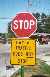
- Signs Located at the
Intersection of U.S. Route 6 and Ed Street in SE Hastings,
NE (August 2001)
|
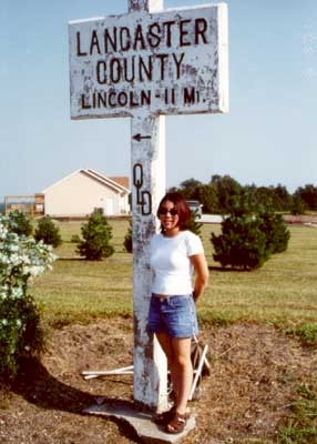
- Jennifer Harrison in Front of This Historic Route
6 Road Sign Located 6 Miles West of Lincoln, NE at the Intersection of Route 6 & SW
140th Street. (August 2001)
|