|
|
 |
|
|
|
- A Division of U.S. Route 6 Tourist Association
|
|
|

|
 |
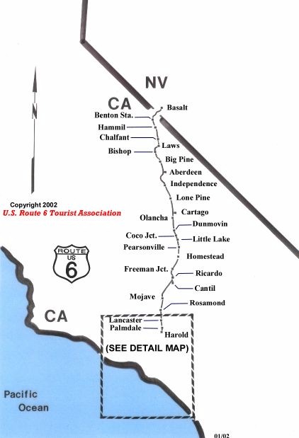
| Aberdeen 93526 - Google Maps
|
|
| Chrysopolis, California - Wikipedia |
|
| Aberdeen, CA |
|
| Acton 93510 - Google Maps
|
|
| Acton Town Council |
|
| Area Information - Aqua Dulce |
|
| Santa Clarita Valley History In Pictures - Acton |
|
| Benton 93512 - Google Maps
|
|
| Benton, California - Ghost Town |
|
| Benton Hot Springs Documentary-YouTube |
|
| Big Pine 93513 - Google Maps |
|
| Big Pine, California - Wikipedia |
|
| Bishop 93514 - Google Maps
|
|
| City of Bishop, California |
|
| Welcome To Bishop, CA | Hotels, Restaurants & Attractions |
|
| Mule Days Celebration – Every Memorial Day in Bishop, CA |
|
| Bishop Chamber of Commerce | Bishop, California |
|
| Bishop Mural Society |
|
| Burbank - Google Maps |
|
| City of Burbank |
|
| Burbank Chamber of Commerce |
|
| Burbank Historical Society |
|
| Warner Bros. Studio Tour Hollywood - Los Angeles, California |
|
| Historical - Bob's Big Boy |
|
| Bob's Big Boy documentary video - 6:22 |
|
| Cantil - Google Maps |
|
| Cantil, California - Wikipedia |
|
| Carson - Google Maps |
|
| City of Carson, California |
|
| Carson Chamber of Commerce |
|
| Carson Library |
|
| Cartago 93549 - Google Maps
|
|
| Cartago, California - Wikipedia
|
|
| Cartago - Ghost Town
|
|
| Chalfant Valley 93514 - Google Maps |
|
| Chalfant, California - Wikipedia |
|
| Coso Junction 93549 - Google Maps
|
|
| Coso Hot Springs - Wikipedia
|
|
| Coso Hot Springs and Coso Junction
|
|
| Dunmovin 93549 - Google Maps
|
|
| Dunmovin - Directions
|
|
| Dunmovin - Photograph
|
|
| Forest Park 91351 - Google Maps
|
|
| Freeman Junction 93527 - Google Maps
|
|
| Freeman Junction, California - Wikipedia
|
|
| Freeman Junction - Ghost Town
|
|
| Photo: View from Robber's Roost toward Freeman Junction.
|
|
| Glendale - Google Maps |
|
| Glendale California |
|
| Glendale Chamber of Commerce |
|
| Sons of the Revolution Library |
|
Museum of Neon Art |
|
| Hammil 93514 - Google Maps
|
|
| Hammil, California - Wikipedia
|
|
| Harold 93550 - Google Maps
|
|
| Independence 93526 - Google Maps
|
|
| Lancaster - Google Maps |
|
| Lancaster - The BLVD |
|
| Laws - Google Maps |
|
| Little Lake - Google Maps |
|
| Little Lake - Facebook Page |
|
| Lone Pine 93545 - Google Maps
|
|
| Lone Pine Chamber of Commerce
|
|
| Museum of Western Film History
|
|
| Lone Pine Film Festival - Wikipedia
|
|
| Landing at Lone Pine California
|
|
| History of the Railroads in the Lone Pine Area
|
|
| Filming Location Matching "Alabama Hills, Lone Pine, California, USA
|
|
| Long Beach - Google Maps |
|
| Long Beach - Mayor |
|
| Long Beach - Chamber of Commerce |
|
| US hwy end in Long Beach, CA |
|
|
Long Beach Museum of Art |
|
| Historical Society of Long Beach |
|
| Visit Long Beach: Official Travel Website For Long Beach California |
|
| Los Angeles - Google Maps |
|
| City of Los Angeles |
|
| COUNTY OF LOS ANGELES |
|
| Kathryn Barger - COUNTY OF LOS ANGELES |
|
| Los Angeles Area Chamber of Commerce |
|
| Discover Los Angeles |
|
| Los Angeles - Wikipedia |
|
| Calle Olvera |
|
| Chinese Chamber of Commerce (CCCLA) |
|
| Angels Flight® Railway |
|
| Natural History Museum |
|
| Manzanar - Google Maps |
|
| Manzanar - Ghost Town |
|
| Manzanar National Historic Site |
|
| Mojave 93501 - Google Maps |
|
| Mojave, California - Wikipedia |
|
| MOJAVE HISTORY |
|
| The dusty corner of California where airplanes go to die |
|
| Mojave Airplane Graveyard June 2021 |
|
| SpaceShipOne - Wikipedia |
|
| Mojave Air & Space Port - "Imagination Flies Here" |
|
| Olancha 93549 - Google Maps
|
|
| Olancha - Ghost Town
|
|
| Olancha, California - Wikipedia
|
|
| Olancha History
|
|
| Olancha California Camping Death Valley Maps, Eastern Sierra Maps
|
|
| Pacoima - Google Maps |
|
| Pacoima, Los Angeles - Wikipedia |
|
| Nury Martinez - 6th District |
|
| Pacoima Beautiful – Planting grassroots since 1996 |
|
| Palmdale - Google Maps |
|
| Palmdale, CA | Official Website |
|
| Lancaster Chamber of Commerce |
|
| Palmdale, California - Wikipedia |
|
| SR-71 – FLIGHT TEST MUSEUM FOUNDATION |
|
| LA County Library - Antelope Valley Bookmobile |
|
| Pearsonville 93527 - Google Maps
|
|
| Pearsonville, California - Wikipedia
|
|
| Pearsonville, Hubcap Capital of the World
|
|
| Ricardo - Google Maps |
|
| Ricardo, California - Wikipedia |
|
| Red Rock Canyon State Park |
|
| Rosamond 93560 - Google Maps
|
|
| Rosamond CA Home Page
|
|
| Rosamond Municipal Advisory Council Meeting Agendas & Minutes | Kern County, CA
|
|
| EFBC's Feline Conservation Center
|
|
| FastLane - raceschool.com
|
|
| Rosamond Community Services
|
|
| San Fernando - Google Maps |
|
| City of San Fernando |
|
| San Fernando, California - Wikipedia |
|
| Historical Site - The Mission San Fernando |
|
| San Fernando Valley Historical Society |
|
| Santa Clarita - Google Maps |
|
| City of Santa Clarita, CA |
|
| SCV Chamber of Commerce |
|
| City of Santa Clarita Trails |
|
| Santa Clarita Swap Meet |
|
| Historic Route 6 - Visit Santa Clarita |
|
| Sleepy Valley 91390 - Google Maps
|
|
| Sleepy Valley, California - Roadside Thoughts
|
|
| SCVHistory.com LW2647 | Sleepy Valley | Castle Oaks Garage (Le Chene), 1920s
|
|
| Solemint 91387 - Google Maps
|
|
| SCVHistory.com LW2093 | Canyon Country | Solemint Store, 1950s-1970s
|
|
| US 6 – Solemint Junction
|
|
| Beales Cut
|
|
| Sun Valley - Google Maps |
|
| Sun Valley, Los Angeles - Wikipedia |
|
| Sun Valley, CA Information |
|
| Sylmar - Google Maps |
|
| Sylmar, Los Angeles - Wikipedia |
|
| Sylmar, CA Information |
|
| Sylmar - Los Angeles, CA - Niche |
|
| The Oaks - Google Maps |
|
| The Oaks, Mendocino County, California - Wikipedia |
|
| Vincent - Google Maps |
|
| Vincent, California - Wikipedia |
|
| White Heather - Google Maps |
|
| White Heather, California - Roadside Thoughts |
|
| Wilmington - Google Maps |
|
| Wilmington Neighborhood Council |
|
| Wilmington Chamber of Commerce |
|
| The Banning Museum |
|
|
|